
AEC: Architecture, Engineering & Construction
Terry Kilby has worked hand in hand with the AEC industries (Architecture, Engineering & Construction) throughout the mid-Atlantic region since 2015. Many architecture and engineering firms were among his first clients and early adopters of aerial imaging technology and continue to utilize his services to this day. From early stages of the design process through construction and into building upkeep and maintenance, aerial imaging has proven to be an invaluable asset providing clients with up to date information about their projects unlike any other technology offering available.
Services Include:
Site Scans capture an entire job site or structure in 3D and 2D through the use of photogrammetry. This is achieved by photographing the location hundreds or even thousands of times from all possible perspectives, and then processing that data set with special software that reconstructs the site in full 3D. Once processed in 3D, there are many deliverable types that can be produced from that data including 3D Point Clouds for CAD software, 2D Orthomosaics for GIS software, textured 3D assets for web or VR/AR display or even physical 3D prints. Multiple sites scans can be grouped together to provide a full 3D or 2D orthomosaic progression view of a site. If you are already scanning your site with the use of terrestrial LiDAR, photogrammetry data can be added to that dataset and provide a much larger coverage area and increased line of sight. Learn More.
Virtual Tours are another great way to document a site. While Site Scans capture the site in 3D, Virtual Tours capture the site in full 360 from multiple locations and allow you to jump from one location to the next and have a virtual look around in any possible direction. Virtual Tours work on all major viewing platforms including mobile devices, desktops and VR Headsets such as the Oculus Quest. The VR experience is fully immersive and allows viewers to feel as if they are on site in person. The 360 panoramic photography can be captured both from the aerial and ground based perspectives and are of extremely high resolution, allowing for an incredible level of zoom to see the details of your site. Learn More.
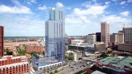
Progression Photography is one of the easiest methods to start utilizing aerial imaging on your job sites. A number of vantage points are strategically selected around your site and then those exact photo locations are captured on a regular schedule during the entire construction process. The image location data saved includes altitude, horizontal location (lat/long), heading (compass direction) and camera pitch and ensures that you see the exact same perspective throughout the entire duration of your project. Learn More.
Inspection Photography is a continuation of services after construction is complete and typically focuses on specific portions of the building that are difficult to monitor through other means. While progression photography may take place as frequently as every week, inspection photography is generally conducted annually or as needed. Learn More.
Bespoke Software Development is often used for large projects that have specific data presentation requirements that simply aren’t met by any of the solutions available on the market today. Multiple data types can be displayed together, in one neat sandbox rather than linking out to several different viewers or platforms. Orthomosaic maps can merge with 360 panos as well as 3D scans and additional client data like CAD drawings and master plans to form one cohesive experience. Platforms include web, mobile and VR/AR. Learn More.
3D Printing extends the digital into the real world by producing a scaled, physical model of your digital files. Objects typically printed range from original 3D CAD files to scans of entire sites or small objects. Prints can range in size from just a few inches to a meter or more and come in one color filament or full color sandstone. Learn More.